Mekong Delta Exploratory Research

Mekong Delta Exploratory Research

EXPLORATORY RESEARCH ON VIETNAM'S MEKONG DELTA

Over the past 10 years living and teaching in Thailand, one of my favorite past times is exploring the Greater Mekong Subregion (GMS).

The GMS an intriguing mix of countries, brimming with diverse peoples and historical geographies, offering countless and affordable adventures.

Among my most memorable travels are those taken in 2014 and 2015 to the Mekong Delta in southern Vietnam.

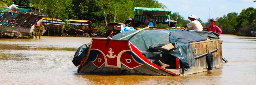
Friendly faces on the Mekong Delta | Click to Southeast Asian Civilization

Photos on this page link to the Southeast Asian Civilization course.

Mekong Delta, Vietnam | Click to enlarge

Agriculture and Fisheries

Mekong Delta is an expansive floodplain of 40,000 sq. km. populated by over 17 million people across 13 provinces. It is responsible for 60% of Viet Nam’s rice production (90% of this is exported) and 60% of the country’s fruit.

There is a large export industry of fish, and 65% of fishery production is sent to the USA. While there is a considerable fishing fleet working the offshore areas around the Delta, the majority of production is based in aquaculture. For the most part, local peoples eat the small fish and sell the big fish.

Mekong Delta food environment

Other important commodities include coconut products and honey. A burgeoning tourism industry is evident in nearly all eras in the Delta, ranging from individuals to small groups to mass tourism.

Exploratory research on the Mekong Delta

Topography and Land Reclamation

Once reaching Viet Nam, the Mekong splits into two main branches at the Delta. The north branch divides into four distributaries and the south branch into three distributaries.

The Delta consists of hundreds of islands formed over millennia of sedimentary deposits; an untold number of waterways create an exotic and dangerous maze of jungles and swamps.

Land reclamation is evident throughout the Delta, with gravel and dirt-laden barges destined for low-lying properties and canal banks. Farmers also dredge local canals every few years and use the silt to reinforce the sides. Busy barge-based cranes used for large-scale dredging of the main river branches are nearly always in view on the horizon.

The ancient network of rural mangrove-lined canals invite visitors to reflect on the country's enigmatic past, while the new palm-lined highway to Saigon represents the fast lane the country is taking to its future at the heart of the economically vibrant and socially diverse ASEAN community.

Crane loading a barge with gravel in the Delta

Vietnamese barge transporting soil for land reclamation on the Mekong Delta

Faith and Religion

There is a heritage of Spanish, Portuguese, French, and to some degree, American missionary influence, and this is evident in Vietnamese language, culture, architecture and religion. For example, Catholic and other denominational Christian churches speckle the banks of the Delta and constitute as much as 15% of the religious base.

However, 60% of the Delta population follows a type of ancestor worship and this may be attributed to an age-old relationship with Chinese culture.

Faith and religion on the Delta

The Delta Road

The government opened up the Mekong in recent years, completing the ‘Delta Road’, a collaborative effort with the Japanese, and this was engineered in part to keep the Delta’s produce fresh and undamaged, particularly rice, fruit and seafood, when they are transported to Saigon overland.

These new transport networks are key as the traditional floating markets are becoming impractical. Thus, there is an ongoing shift from a water-based trade economy to a land-based export economy.

Historically, there were much smaller human populations in the Delta due to the dangers associated with snake and crocodile-infested swamps.

Traditional Delta transport

The "Delta Road" represents an ongoing shift from a water-based trade economy to a land-based export economy

Environment

Winter is the dry season on the Delta and the rainy period is normally during the summer, although the Delta is indeed south of the typhoon belt which impacts central Viet Nam and the Red River area further north.

The water level is higher during the rainy season, and this ‘wet time’ is utilized for fishing, while the ‘dry time’ is best for vegetables and potatoes. Climate change is evident and local farmers explain that nowadays the seasons are not so distinct.

The biodiversity of the region is still wide-open to exploration and inquiry, with thousands of new species discovered in recent years. However, there is an unfortunate war-torn legacy of ‘agent orange’, the chemical defoliant dropped by American forces upstream of the Delta, and as many as 2 million people are affected by it today.

One of the many canals on the Mekong Delta

The watery world of the Mekong delta, Vietnam

Settlement

The Delta was once part of the Funan (68-550 AD) and Chenla (550-760 AD) empires with ties to early Chinese trade networks, and later saw Champa settlements (associated with central Vietnam) and Khmer settlements (associated with Cambodia). Some Khmer still live in the west of the delta region near Cambodia.

According to my Delta guide, the Khmer never actually left the region; rather they mixed and integrated with the North Vietnamese (i.e., the ‘Kinh’ ethnic group) who migrated to the Delta over time.

The feelings of the North Vietnamese about their Delta settlement are represented in the local music which carries sad tones and lyrics, voicing their homesick emotions.

There was also a significant era of assimilation 300 years ago, when Chinese, Vietnamese and Khmer cultures mixed together.

Personal interview with Sombo Manara | Champa Kingdom

Interview with Prof. Dr. Sombo Manara, a leading expert in Khmer ancient history. The interview took place at the Po Nagar Temple in Nha Trang, Vietnam, a 7th - 12th century Hindu temple and vestige of the once powerful Champa Kingdom.

Cham is an Austronesian language, part of a super-family of languages generally associated with the seafaring peoples of the Pacific and Indian Oceans.

Visit Chasing Jade: Archaeology and the Batanes Islands Cultural Atlas to learn more about Austronesian prehistory.

Life and settlement on the Mekong Delta

Cultural Stereotypes

Vietnam is polarized by Hanoi in the north and Ho Chi Minh City in the south, two sprawling urban and cultural centers with unique cultural attributes.

Stereotypically, the north and central populations distinguish themselves as thinking, planning, hard-working, and saving for the future.

In contrast, and as my Delta guide, Nguyễn Minh Phương, himself from the central region, put it, "The people of the Delta live for today, and are sometimes typecast by their northern counterparts as being reliant on the good weather, having strong physical features, and a sweet palate."

Daily life on the Delta

Life on the Delta Road

Next generation on the Delta

Water color painting for sale on the Delta

Travelers, Traders and Invaders

The Mekong Delta is a beautiful place to visit, an exotic tropical landscape steeped in ancient tradition with modern geographical significance. At 4,350 km, the Mekong is the world’s 12th-longest river, the lifeblood of mainland Southeast Asia – a trans-boundary network known as the ‘Greater Mekong Subregion’ (GMS).

The Mekong derives its name from the Sanskirt word ‘ganga’ after the Ganges River in India, and the toponym evolved in Thai and Laotian languages to ‘Mae Nam Khong’, literally ‘mother water Khong’.

The mouth of the Mekong called to traders, invaders, and great cultures and philosophers from India and China, providing them safe harbor and entry to upstream riches, including Cambodia’s fish-laden lake, the ‘Tonle Sap’, and the Khmer Kingdom at Angkor.

Coined by the French as "Indochina", friends, foods and freedoms await in the mighty Mekong Delta, an eclectic blend of culture, race and religion along Southeast Asia’s greatest of rivers.

Vietnam | Modified from: portal.gms-eoc.org/maps | Click to enlarge

I hope you enjoy my photos and the information in the links provided. If you feel motivated to travel to the Mekong Delta, please let me know – I’d love to hear from you.

–Steven Martin

Special thanks to my Delta guide, Nguyễn Minh Phương for his time and insight, which helped to make this short article possible.

If you’re traveling to Ho Chi Minh City, he can be reached at: guyenminhphuongjp@gmail.com

Nguyễn Minh Phương, certified Mekong Delta guide

Nguyễn Minh Phương, certified Mekong Delta guide

Pakistan Gandhara & Indus Valley Civilizations

Pakistan Gandhara & Indus Valley Civilizations

EMPIRE OF THE SPIRIT | PAKISTAN AND THE INDUS VALLEY CIVILIZATION

At 15,397 feet above sea level, the Khunjerab Pass is the highest paved international border crossing in the world, and our ancient, rattling public bus creaked and groaned up to it through spectacular mountain scenery, around hairpin bends with terrifying drops...

Welcome to part II of my Journey to the West, a six-week overland trip from Beijing, China, to Islamabad, Pakistan.

Click on photos to enlarge.

View of Hidden Peak (Gasherbrum I) near the Sino-Pakistani border at sunset | Karakoram Range | 8,080 m/26,510 ft

Physical Map of Pakistan (German version) | Click to enlarge

The Karakoram Highway to Pakistan | Tashkurgan Tajik Autonomous County, Xinjiang, China

Passing through the Tashkurgan Tajik Autonomous country on the notorious Karakoram Highway (KKH), I spent one night at this final Chinese outpost at 3,090 m/10,140 ft on my Journey to the West. According to the Chinese bus driver, the Pakistan border was an estimated 10 hour drive, depending on the changing conditions of the road.

Tashkurgan Tajik Autonomous County, Xinjiang, China

Tashkurgan | Tajik Man

Tashkurgan | Tajik Woman

Much of the Karakoram Highway was a narrow, rugged track, chiseled out of an unstable complex of different types of rock formed through violent seismic activity and extreme weather. I witnessed massive landslides, ice avalanches, and unpredictable flooding, and these events delayed the two-day crossing from Kashgar, China, several times.

Karakoram Highway | Kashgar, China, to Islamabad, Pakistan

From interpretation signage posted along the way, I learned that the Karakoram Highway was developed by Pakistani and Chinese engineers, and took 20 years and over 1,000 lives to construct, with particular hardship occurring in the remote areas of Pakistani‐controlled Kashmir.

Karakoram Highway Memorial

Indeed, things didn't always go as planned when travelling the Silk Road, a common theme in the journals of ancient Chinese monks, such as Xuan Zang, the who traveled this very route in the mid-seventh century.

Half way to the Pakistan border from Tashkurgan, the bus was forced to stop at a section of road that had been washed out from a flash flood during the night.

In the spirit of the monks and merchants of yesteryear who had experienced great challenges on the Silk Road, I felt it was a great opportunity to get off the bus and get my hands dirty. Fortunately, the road workers allowed me to help them construct the cages of rocks in wire needed to temporarily repair the road so we could pass.

Roadwork on the Karakoram Highway near the Sino-Pakistani border after an overnight flash flood

The Khunjerab Pass | Sino-Pakistani border

At 4,693 m/15,397 ft above sea level, the Khunjerab Pass is the highest paved international border crossing in the world, and our ancient, rattling public bus creaked and groaned up to it through spectacular mountain scenery, around hairpin bends with terrifying drops.

Khunjerab Pass, Sino-Pakistani border crossing | 4,693 m/15,397 ft

The Hunza Valley | Gilgit-Baltistan

The first evening in Pakistan, I arrived in the Hunza Valley with my new Pakistani guide, Iqbal, and driver, Usman (featured image at top of page). Waking up at first light and walking outside, I was stunned by the view of Rakaposhi, towering 7,788 m/25,551 ft above, surrounded by deep blue sky.

Rakaposhi | 27th highest mountain in the world | 7,788 m/25,551 ft

The Hunza is a high-mountain sanctuary fed by glacial streams and known for the longevity of its people. In the morning, I woke to views of snowcapped mountain peaks, melting glaciers, and fertile valleys with apple, apricot, and pear orchards. The headwaters of the fertile Hunza River, rich with minerals from the high glaciers, sparkled on the valley floor, it's waters flowing to join the Indus from Tibet.

Hunza Valley, Gilgit-Baltistan region, Pakistan | Averaging 2,500 m/8,200 ft

Landslides from sedimentary rock, shale, and glacial debris shaken lose from earthquakes characterize the landscape, and it is logical to assume this led to the name Karakoram, Turkish for black gravel, given by early Central Asian traders. Today, K for Karakoram, stands for the second highest mountain in the world, K-2.

My driver, Usman, said to me, with his eyes peeled to the road, “I use both eyes, one for the road, one for falling rocks.”  He suggested buckling my seat belt: “Muslims believe that life is very precious.”

A landslide blocks our travel south | Karakoram Highway | Pakistan

The junction point of three greatest mountain ranges of the world

Following the Gilgit River south, we reached a place that geographers dream about – the  junction point of the three highest mountain ranges in the world.

In the photo below, the ranges are as follows: Himalayas (right), the Karakoram (distant center), and the Hindu Kush (left).

This was also my first glimpse of the Indus River (right) as it emerges from the Tibetan Plateau. The Gilgit River is on the left.

Junction point of three greatest mountain ranges of the world | Himalayas (right), Karakoram (center), and Hindu Kush (left)

Taxila | Archaeological site visit

As described on my Silk Road page, the UNESCO-listed Taxila was one of the most ancient universities in the world, where people from all over Asia came to study medicine, religion, and science. Instruction was available in at least five different languages, and this multicultural environment contributed to the pre-eminence of Taxila as a center of learning by the 5th century BCE.

Taxila, Pakistan | Excavated remains of the ancient Greek city at Sirkap, founded by Bactrian King Demetrius in 190 BCE

At the height of the Maurya Empire in 250 BCE, King Ashoka recognized the significance of Taxila as an international city at the crossroads of Persia, India, and China, and declared it the provincial capital of his empire.

The Jaulian Monastery

The Jaulian Monastery is the treasure of Taxila, an ancient education and art center with preserved stupas depicting Greek, Indian and Chinese cultural images. The site was of special interest to archaeologist Sir John Marshall (discussed below).

A place of ancient pilgrimage, my local Muslim guide compared it to Mecca, "Many people in history made a great journey to reach this location."

Jaulian Monastery | Taxila Archaeological Site, Pakistan

Interview at Jaulian Monastery | Taxila

Stupas at Jaulian Monastery | Taxila

Sir John Marshall (1876-1958)

Any account of the research and excavations at Taxila, and the Indus Valley Civilization sites of Harappa and Mohenjodaro, would be incomplete without mentioning Sir John Marshall, the Director-General of the Archaeological Survey of India from 1902 to 1928. He was the first person in modern times to recognize the significance of these abandoned cities, and worked extensively to document, protect, and popularize these mysterious ancient sites.

During my site visit at Taxila, I had the opportunity to personally interview the grandson of Basharai Khan, who was Sir John Marshal's personal assistant. Alongside learning about Marshal's fieldwork, I was also fortunate to visit the Taxila museum, which he founded in 1918.


Portrait of Sir John Marshall (1876-1958) | Taxila Museum, Pakistan

The works of Sir John Marshall in PDF

John Marshall’s outstanding work is currently online and publicly available at: Archive.org.

Below, I have provided direct links to three relevant books from Sir John Marshall’s legacy.

  • Marshall, J. (ed.) (1931). Mohenjo-Daro and the Indus Civilization. | 30Mb
  • Marshall, J. (1951). Taxila: An illustrated account of archaeological excavations. Cambridge: Cambridge University Press. | 65Mb
  • Marshall, J. (1960). The Buddhist art of Gandhara: the story of the early school, its birth, growth and decline. Cambridge: Cambridge University Press. | 65Mb

Gandhāra Civilization | Greco-Buddhist art

Taxila was a key site where the ancient Greeks met the Buddhists, a cultural coincidence that occurred at the dawn of Mahāyāna Buddhism and the development of the Gandhāran civilization. Gandhāra reached its zenith during the Kushan period in the 2nd century AD.

Fasting Buddha, Gandharan period, 2nd Century CE | Lahore Museum, Pakistan

Click on the links provided here to view my PDF presentations of Gandhara and Taxila, featuring site visits to the Second City of Sirkap, founded by Demetrius in 190 BCE, and the ruins of Jaulian, a two-thousand-year-old monetary which served as an education center.

Academic Resource Online | Gandhara Sculpture from Pakistan Museums

In 1960, a comprehensive exhibition of Gandharan sculpture was brought to America. Subsequently, sixty-five free-standing and relief sculptures dating from the 2nd -5th centuries A.D. were photographed, catalogued and published as Gandhara Sculpture from Pakistan Museums. The book visually represents the golden age of Gandhara, when the flourishing Buddhist colonies created some of the first representations of the Buddha in human form. Benjamin Rowland, Harvard University,1960

Sakyamuni's First Meeting with a Brahmin | Late 1st century, fine-grained schist, Peshawar Museum

The Indus River Valley Civilization | Harappa

Continuing to travel south from the Taxila archaeological sites, I began to understand what makes the Indus River Valley such a unique area of historical significance, and why the entire subcontinent is named after it. This valley was the cradle of many great Indian cultures, not only Hindu, Jain and Buddhist, but also older and more mysterious cultures whose scripts remain undeciphered.

The Pashupati Seal | Meditating Yogi with horned headdress surrounded by animals | Indus Valley Civilization | Moenjodaro

A day's drive south from Taxila and the capital city of Islamabad, I felt like a time-traveler, heading back thousands of years before the 2000-year-old Gandhara Civilization to experience first-hand the 5000-year-old Harappa archaeological site and the Indus Valley Civilization, an enigmatic slice of ancient history that has profoundly influenced the way people think throughout Asia and the world.

Harappa | Archaeological site visit

Beginning over five thousand years ago, the UNESCO-listed site of Harappa was once one of the world’s most important cities and cultural centers.

Through personal interview with my Pakistani guide, Shafik Malik, he told me a story of a young Sir John Marshall working on a British railroad project in the area:

"Villagers were bringing wheelbarrows loaded with red bricks for use as fill under the railroad tracks, and Marshall, suspecting that they looked unusual, asked where they came from. The villagers told him about a place where there were scores of old bricks spread out all over the land, and no one had idea where they were actually from. Marshall went to investigate..."

Since the discovery and excavation of the site in 1921 by Marshall, Harappa has come to be recognized as one of the oldest and most important civilizations and archaeological sites in the world.

Red bricks form foundations of ancient workshops at Harappa | Indus River Valley Civilization

UNESCO divides Harappa’s history into five key phases:

c. 3300-2800 BCE – Ravi
c. 2800-2600 BCE – Early Harappan
c. 2600-1900 BCE – Harappan
c. 1900-1800 BCE – Transitional
c. 1800-1300 BCE – Late Harappan

5,000-year-old red Harappan bricks | Indus Valley Civilization

Shafik Malik | Pakistani Guide | Harappa Archaeological Site | June 24, 2001

As explained by Mr. Malik and outlined in the interpretation signage at the site, the earliest settlement at Harappa was the Ravi phase, founded on an ancient levee of the river Ravi between 3500 and 3300 BCE.

With more than a decade of experience working at Harappa, I wanted to know more about Malik's personal feelings about the site:

“At 2600 BC the Harappa Civilization is magnificent, a great city center with monumental public buildings, craft areas, bazaars, and connecting trade routes to the world... Small manufactured seals still puzzle us with undeciphered inscriptions… When I think about Harappa, I get a mystic feeling.”

Ravi/Early Harappan Phase 3300-2600 BCE | Click to PDF slides

Archaeological work on the Ravi phase has revealed that these early inhabitants imported stone from what is now Afghanistan and western India, and shells from the Arabian Sea to make beads. They manufactured earthenware vessels and figurines of clay by hand.

Water well and sewage systems at the Harappa archaeological site

Red bricks of Harappa

Locals at Harappa

Pakistan Photo Journal | June 2001

The 15 photos shown below were taken during the drive south from the Sino-Pakistani border to Faisal Mosque in Islamabad.

Welcome to Pakistan | International border police

Karakoram Highway | People's Republic of China & Islamic Republic of Pakistan | 1958-1978

Entering Pakistan en route to the Hunza Valley | Karakoram Highway | Gilgit-Baltistan | View from the bus window

English-made Bedford truck decorated with Pakistani Islamic art

Usman | Pakistani driver and international guide

Pakistani youth | Hunza Valley

Hopper Glacier | Naga Valley | Gilgit-Baltistan

Hunza Valley stream | Gilgit-Baltistan

Upper Indus River Valley | Road of Alexander the Great still visible on the opposite bank above the river

Nanga Parabat | Killer Mountain | Third highest peak in the world

Gem stones for sale at Nanga Parabat

Upper Indus River Valley | Gilgit-Baltistan

4th-8th Century Buddhist rock carvings above the Indus River | Shatial (west of Chilas), upper Indus Valley | Sogdian Iranian Civilization

Crossing the Indus by single-cable chairlift | Shatial

Pakistani kids | A few hours north of Islamabad

Faisal Mosque | Islamabad

Mohenjo Daro 101 | National Geographic 3:14

Thank you for visiting my Pakistan Page.

If you feel motivated to know more about the Silk Road or other Learning Adventures, or would like to arrange for me to give a public talk, please let me know – I’d love to hear from you.

–Steven Martin

Skateboarding the Great Wall 万里长城

Skateboarding the Great Wall 万里长城

SKATEBOARDING THROUGH TIME ON THE GREAT WALL OF CHINA

Skateboarding on the Great Wall of China in 1995 | Badaling 八达岭 万里长城

Learning Adventure for Students of 806-123 / 809-122 Eastern Civilization

Click on images to enlarge.

Backstory – My first time to skateboard on the Great Wall

Between 1995 and 2002, I studied Chinese philosophy during summers at Peking University. Hiking – and skateboarding – on the Great Wall quickly became my favorite activity, outside of attending lectures and campus life.

Each time I traveled to the Wall, I learned something new, and the more I visited different areas, the more I wanted to learn about the history and culture behind this amazing symbol of the Chinese people.

Catching air at Badaling Great Wall 八达岭 万里长城

Skate the Wall

Our sleek private taxi wove its way between big trucks and buses, tiny cars and vans, zooming motorcycles and buzzing scooters. The silent bikes and carts yielded without stress, smoothly avoiding us as if doing Tai Chi.

Radiating from Beijing, the traffic faded into tranquility. We, students from the University of Hawaii, headed due north with our driver, a kind-hearted Chinese man with dark glasses and a love for classic Western rock music.

We gave him a thumbs-up and nodded when his stereo played Pink Floyd’s Another Brick in the Wall.

En route to the Great Wall with our favorite taxi driver | 2002

Around us, wheat and corn formed a checkerboard landscape, as hills graduated to small mountains with riverbanks planted with weeping willows, walnut and peach trees, thriving under deep blue sky. Slender poplar trees cast zebra-striped shadows which flickered on our faces while we blazed on.

It was a perfect day to skate the Wall.

Skateboarding on the Great Wall | 2001

Philosophical Attitudes

Just as philosophical attitudes of Chinese and Americans may differ, so too have their reactions to my skating on the Wall.

Photos from my early trips in 1995 shocked some Western friends to contend, “You mean they allow you to do that?”

Badaling Great Wall | 1995

In contrast, Chinese friends were enthusiastic and positive.

The first time I skated the Wall, a guard stationed at the Wall shouted in Mandarin and took my board. To my surprise, he traded me his rifle for my skateboard and tried to ride it, shooting down the hill out of control, skidding to a halt, and tearing holes in his clothes.

Bruised and bleeding, he reacted with a smile, and raced up the hill for another try.

World's oldest skateboard park

Unexpectedly, we had a marvelous hour together, sharing the moment and cultural experiences.

I realized that the function of the Wall had changed from combat to sport, from exclusive to inclusive, from military to peaceful – attracting tourists and hikers, students and teachers, philosophers and politicians.

The Wall had become fun and exciting, as if suddenly transformed into the world’s greatest skatepark.

Skateboarding at the Great Wall

Meng Jiang Nu

In contrast to the touristic carnival-like atmosphere experienced at many sections of the Wall today, truth is, the Great Wall is no laughing matter.

Hiking the Wall on a hot summers day, exhausted at the onset of heat stroke, I could feel the blood, sweat and tears of the conscripts and prisoners who built it.

Sometimes called the "World’s longest tombstone," the Wall was a place where men were sent to toil and suffer until they died and their bodies were buried near the Wall.

Hiking on the Great Wall of China, north of Beijing

Set in the Qin dynasty (221BC-206BC), one story still resonates among the collective memory of the Chinese, the dramatic separation of a loving couple and their tragic ending as a result of building the Wall.

Ancient literature, paintings, poems, music, and modest temples throughout China, Japan, and Korea honor the heartbreak of Meng Jiang Nu (Lady Meng Jiang), who searched the entire length before finding her beloved dying husband, Fan Qiliang. Legends tell she cried so hard that the wall collapsed where she found him.

Modern cartoons, videos and films in recent years continue to romanticize her story, representing the ruthlessness of the emperor, the tragedy of the Great Wall, and the kindness of a gentle woman.

Lady Meng Jiang and the Great Wall | Source: Stent, 1878

Her story is a recurring theme in Chinese folklore, with literary evidence dating back more than two-thousand years. One of the many treasures of Chinese historical literature, a Bianwen manuscript (c. 9-11 century) of the story was discovered at Dunhuang, Gansu province, an important stop on the Silk Road.

The story of Lady Meng Jiang | c. 9th-11th century Bianwen manuscript

Iconic guardian of China

A great unification of the Wall took place under Emperor Qin Shi Huanghi, the legendary ruthless ruler who founded the Chin Dynasty (221-206 BC) and hence gave his name to China. He also left behind his personal terracotta army of Xian, the larger-than-life clay soldiers built supposedly to guard him in the afterlife.

A continuous project, the Chin fortifications that began in strategic mountain passes now string together to stretch thousands of miles across China, from Heilongjiang Province in northeast China, winding westward to Jaiyuguan, Gansu Province, in the Gobi Desert.

View from a garrison | Jinshanling Great Wall

The Wall is an iconic guardian of China, towering over the fertile river-valleys and plains of the south, protecting them from invasion by the marauding bandits of the Mongolian plateau to the north.

The northern face of the Wall is always sheer, often 30 feet tall, or perched on the rim of a high cliff, while the southern face is sometimes only ground level.

Today, the Wall with all its branches, if placed end to end, would stretch more than 30,000 miles.

Jinshanling, north of Beijing, a 10 kilometer stretch of unrestored Wall

The World's first internet

The Great Wall can be justly described as the world's first information superhighway. Timely information could be sent across the entire country in a single day – smoke by day, and fire by night.

The Wall served as a secure connection network, offering enough band-width to allow soldiers to ride two-abreast and travel in both directions, garrisons serving as safe terminals, battlements providing the firewall, vats of hot oil ready to be poured on the heads of potential hackers.

From the east, China streamed live to the world – and from west, the world steamed live to China.

The Great Wall – Connecting east and west

The Silk Road

The Great Wall was heavily fortified, serving as the military power line of the Silk Road as early as the Han Dynasty (206 BC-AD 220), when caravans of horses and camels transported men and women, trade wares and silks, plants and animals, technologies and religions. Han Dynasty garrisons extended the reach and power of the Great Wall system deep into the desert areas of western China (see photo below).

Han Dynasty (206 BC-AD 220) garrison on the ancient southern Silk Road

Perhaps no other exchange of information was as profound as what occurred leading up to the Golden Age of Chinese philosophy (Tang Dynasty, AD 618-907), when Indian Buddhism flowed into China along the trade routes of the Silk Road, carrying information and ideas that changed how the Chinese, Japanese, and Koreans think.

For example, ancient Buddhism and art, illuminated with Greek and Persian influences, flourished in Western China, a sign that east-west cultural communication and collaboration is much older, and much better developed, than previously thought. (Visit my Silk Road and Pakistan pages to learn more about Grecco-Buddhist culture and China, or see the works of Sir Aurel Stein and Sir John Marshall).

Uyghur dancer | Turpan, Xinjiang

Jiāyùguān Fort

The Ming Dynasty (AD 1368-1644) earned the reputation for hosting China’s most masterful wall builders, creating faultless square-cut bricks, which still appear clean, tight, and engineered into perfect function.

The most famous Ming Dynasty wall remains Jaiyuguan Fort, the western terminus of the Great Wall in the Gobi Desert, fabled end – or beginning – of the civilized world, depending on one's perspective.

Sunrise at Jiayuguan Fort | 2001

One story of Jaiyuguan Fort tells of a architect placed in charge of construction. Upon ordering the massive number of bricks required to build the fort, which he calculated down to a specific number, he was warned that it had better be enough. With confidence he agreed and added one brick to the order just in case.

When the complex was completed, only one brick remained. The story is a testament to Chinese ingenuity.

Four characters inscribed near the front gate roughly translate to mean: Strongest fort under heaven.

Jiayuguan Fort | Ming Dynasty | AD 1368-1644

Acuity and continuity

Layers of architecture attest to the acuity and continuity of Chinese culture and philosophy as the wall, like the art of the earth, rises in chronological order from a subterranean foundation.

I have stood at sections where the base was built during Chin Dynasty, the middle during Han, the upper during Ming, the watchtowers Qing (AD 1644-1911) while the surface was only one week old.

I’ve watched as farmers bashed bricks off the Wall with sledge hammers, loading them on donkey carts to use on their farms, while in the distance I could see contemporary building crews adding a fresh face, handrails, stairs, and toilets for tourists.

Farmer at Jinshanling Great Wall

Can we see the Wall from Space?

It is often said that the Great Wall is the only man-made structure recognizable from space, but when I asked Colonel Scott Horowitz of the US Air Force, commander of four Space Shuttle missions, he told me:

“It's nearly impossible to see the Great Wall, even from low orbit, because the color of the bricks and building materials match the colors of the corresponding landscapes, and also due to the heavily polluted skies over China.”

Scott said that it was just about possible to make out the line traced across China by the Wall, with a little imagination, on a crystal-clear day. On the other hand, he said that the Great Pyramid, in Giza, Egypt, was clearly visible throughout the hours of daylight, and especially in the early morning and late evening, due to its long shadow.

Surf Doctor Steven with NASA Astronaut Scott Horowitz in 2002

Above Huanghuachen Great Wall | 2001

Prof Yang Xin | Peking University

Returning to Peking University after a trip to the Wall, I asked my philosophy professor, Yang Xin, a specialist in Great Wall aesthetics, “Why Great Wall, and not simply long wall or border wall?”

He explained, “Although the original name may have implied long wall (wall of 10,000 Li), the significance matured and greatness was attributed. One brick is only one, with function limited, yet when they combine, a great animation is formed, just like the Chinese culture.”

He added, “The Wall unifies mankind with heavenly forces, as if an enormous composition of cursive calligraphy, its aspects constantly altered through time and seasonal changes."

Professor Yang Xin, specialist in Great Wall aesthetics | Peking University

We’re all just bricks in the Wall

When I first visited the Wall in 1995, I was shocked by its grandeur; later its spiritual aspects overcame me as I saw it as a symbol of both the Chinese people and the human race.

From some viewpoints the Wall looks like a coiling dragon, reaching to the sky, riding on the backs of mountains. From other angles, it resembles a growing plant, following the earth’s natural curves.

Simatai 司马台 Great Wall

After skating the Wall, I could imagine the ancient battlements reflecting rhythmic, piano-key-shaped shadows playing rock-n-roll upon the earth, zigzagging up the mountain in harmony with nature.

Ultimately, the greatness of the Great Wall stands for the greatness of humanity, as well as the suffering of humanity – we’re all just bricks in the Wall. ♦

Jiayuguan fortress, westernmost garrison of the Ming Great Wall | 2001

Thank you for visiting my Great Wall Learning Adventure page.

I hope you enjoy the photos and the information in the links provided. If you feel motivated to learn more about this topic or would like to arrange for me to give a public talk, please let me know – I’d love to hear from you.

–Steven Martin

Other skating, sandboarding, surfing fun in China...

Sandboarding at the Singing Sand Dunes in Dunhuang, China | 2001

Surfing behind a water buffalo in a Chinese rice paddy | 1997

Surfing small waves on an island near Shanghai, China | 1997

Hiking with students from the University of Hawaii | Jinshanling Great Wall | 2000

Skateboarding at Huanghuachen Great Wall | 2002

Skateboarding with Chinese youth | 2001

Short Videos

TED-ed | 4:29

Smithsonian Channel | 4:52

Silk Road Journey to the West  絲綢之路

Silk Road Journey to the West 絲綢之路

Teaching Demo | Silk Road | Eastern Civilization

TRAVELING IN THE FOOTSTEPS OF XUANZANG 玄奘

THE SILK ROAD 絲綢之路 Sīchóu Zhī Lù

AND MY JOURNEY TO THE WEST 西游记 Xi You Ji

Kashgar, Xinjiang, China | Silk Road

1995 Xi'an to Kashgar

I first traveled along the Chinese Silk Road in 1995, on a trip organized by Professor John Cheng through the University of Hawaii at Hilo (UHH). We journeyed by bus, train and short flights. Reaching Kashgar on China's westernmost border just in time for the Sunday Bazaar, I vowed to return one day with more time to explore.

2001 Xi'an, China, to Delhi, India

In June, 2001, I returned to explore the Silk Road. On this trip, I traveled overland from Xi'an to Kashgar, China, and across the Karakoram Mountains to Pakistan (see Silk Road Part II, Pakistan).

Although a long journey across deserts and mountains, it was certainly not as difficult as in the past. By 2001, modernization in Xinjiang had brought hotels, tourist amenities, and transportation networks, including a new rail link between Urumqi and Kashgar.

I hope you enjoy the highlights of the 1995 and 2001 photo journals below, and find the links to Silk Road maps, presentations and resources helpful.

For more information, please contact me or visit my university course at Eastern Civilization.

Jiayuguan Fort, Great Wall of China | A beacon of Eastern civilization and culture


Teaching | My course in Eastern Civilization

Sir Aurel Stein | Photo 1909

I have been sharing my Silk Road experiences with students of all ages for over twenty years. I am interested in the early works of European explorers, particularly Sir Aurel Stein (1862-1943).

Stein's archaeological and geographical work is well represented in his 1933 publication: On Ancient Central Asian Tracks: Brief Narrative of Three Expeditions in Innermost Asia and Northwestern China.

Many of Stein's original works are currently royalty-free and available on Archive.org.

1933 Chinese Silk Road Map by Aurel Stein | Innermost Asia | Click to enlarge


1995 Experience | The University of Hawaii Silk Road Study Tour

The photos shown here are highlights from my first trip along the Silk Road.

The travel began at the Big Wild Goose Pagoda in Xian, and ended at the Kashgar Bazaar, also known locally as the Sunday Market, and now officially known as the International Trade Market of Central and Western Asia.

Click on photos to enlarge.

1995 Highlights

Monks at the Big Wild Goose Pagoda in Xian

Big Wild Goose Pagoda | Xi'an

Rainy start on our Journey to the West | Xi'an

Riding the Iron Rooster to Western China

Exploring the Gobi Desert at 33 years old

Jiayuguan Fort | Western end of the Ming Dynasty Great Wall

UH Hilo Prof John Cheng | Dunhuang, Gansu Province

Turpan and Urumqi | Xinjiang Uyghur Autonomous Region

Flaming Mountain, from the epic tale, "Journey to the West"

Farmer in Turpan | Eastern Xinjiang

Taklamakan Desert | Xinjiang

Kazakh yurts in the Tianshan | Heavenly Mountains

Toordi Ashan | Our Uyghur driver in Urumqi, Xinjiang

Tianshan | Flight from Urumqi to Kashgar

Kashgar | Xinjiang Uyghur Autonomous Region

Islamic culture | Kashgar

Musical instruments for sale | Kashgar

Knife seller | Kashgar Sunday Market

Islamic culture | Kashgar Sunday Market

Sunday Livestock Market | 1995

Tobacco seller | Kashgar

Afaq Khoja Mausoleum (c. 1640) | Kashgar


My 2001 Silk Road Independent Study Project

In the summer of 2001, I made an agreement with the University of Hawaii at Hilo (UHH) to conduct independent research on the Silk Road. I proposed to travel overland from Xian, China, to Delhi, India.

My Liberal Studies Adviser, Prof. John Cheng, agreed, providing I visited Harappa, the Indus River Valley Civilization site, and Taxila, the Gandhara Civilization site.

Taxila was one of the most ancient universities in the world, where people from all over Asia and the Middle East came to study and teach. At least eighteen subjects were covered, including medicine, religion, and science. Instruction was available in at least five different languages, and this multicultural environment contributed to the pre-eminence of Taxila as a center of learning from the 5th century BC until the 2nd century AD.

Taxila was a key site where the ancient Greeks met the Buddhists, a cultural coincidence that occurred at the dawn of Mahāyāna Buddhism and the birth of the Gandhāran Civilization.

I was fortunate to be able to visit the Sirkap archaeological site at Taxila, evidence of an ancient Greek city in South Asia.

Sirkap archaeological site | Taxila, Punjab, Pakistan

Visitors today can explore the ruins of a two-thousand-year-old university, and stroll around the Taxila Museum filled with unique art history.

I kept a comprehensive photo journal of my travels, and after returning and presenting my photo journal at the university auditorium I earned enough credits to complete my undergraduate studies at the University of Hawaii.

Journey to the West  西遊記

My plan was to follow in the footsteps of the Buddhist monk Xuanzang (玄奘) (c. 602–664), who traveled to India in the 7th century, during the Tang Dynasty, and kept a detailed account of his travels.

His journal, Great Tang Records on the Western Regions (大唐西域記), is an outstanding treasure of Chinese history.

Nine hundred years later, Xuanzang's true story was brought to life in the16th century Chinese novel Journey to the West (西遊記), one of China's "Four Great Classical Novels."

Journey to the West | Xuanzang in the 16th century Chinese classic

Journey to the West is a tall tale retracing Xuanzang's travels with an unlikely group of companions, namely the tricky and powerful Monkey King, the greedy and ravenous Pigsy, and the hideous and obedient Friar Sand. Mixing fact with fiction, the story incorporates Chinese Buddhism, Taoism, Confucianism and folklore into the groups' improbable pilgrimage of spiritual enlightenment.

Xuanzang travel map | Click to enlarge

National Geographic | Treasure Seekers: China's Frozen Desert

Based on the lives of Sir Aurel Stein and Xuanzang: "As commerce flourished along the Silk Road, Central Asia became a melting pot of cultures. Here on the edges of the Taklmakan Desert, an exotic blend of Indian, Mongol, Chinese, and European influences fueled an astonishing cultural Renaissance. In the 7th century, a Chinese monk, Xuanzang, plunged into the desert while on a Buddhist pilgrimage to India..."

2001 Journal Highlights

Starting in Xian, at the Big Wild Goose Pagoda built in Xuanzang's honor, I began my own journey. I tried to visit the same cultural sites and physical landscapes, and to keep a journal, like he did. While his trip to India and return took 15 years or more, I had just two months.

The photos shown here are highlights from the Chinese leg of the journey, placed in chronological order.

Click on photos to enlarge.

Statue of Xuanzang | Big Wild Goose Pagoda in Xi'an

Bell Tower in Xi'an | Beginning of the Silk Road as a trade route

View from the train | Xian, Shaanxi Province, to Jiayuguan, Gansu Province

Sunrise at Jiayuguan Fort, Great Wall | Gansu Province

Jiayuguan Fort | Western end of the Ming Dynasty Great Wall

Singing Sand Dunes | Dunhuang

Dunhuang | Mogao Caves

Han Dynasty (206 BC-AD 220) garrison on the ancient southern Silk Road

Uyghur man with his taxi at the Gaochang ruins

Uyghur youth at the Gaochang ancient ruins

Uyghur dancer | Turpan, Xinjiang

Raisins for sale in Turpan

Bezeklik Thousand Buddha Caves

Urumqi, Xinjiang Gateway to the Tianshan

Hui culture | Urumqi

Frank Li | Hui culture in Urumqi

Kazakh family erecting their yurt | Tianshan

Kazakh family arriving at lower pastures | Tianshan

Home for the summer | Lower pastures of Tianshan

Kashgar, Xinjiang China's western frontier town

Overnight train | Urumqi to Kashgar

Kashgar International Trade Market

Livestock market | Kashgar Sunday bazaar

Chili peppers for sale | Kashgar

Kashgar knives at the bazaar

Uyghur youth at the Kashgar Sunday bazaar | Xinjiang Province

Watermelon seller | Kashgar Sunday bazaar

Working at the Kashgar bazaar

Wooden pitchforks for sale | Kashgar bazaar

Id Kah Mosque (c. 1442)

Islamic culture at the Id Kah Mosque

Reading the Koran across from the Id Kah Mosque

Yusuf Balasaguni | 11th century Islamic philosopher

Yusuf Balasaguni Mausoleum | Kashgar

Online resources

Thank you for visiting my Silk Road Learning Adventure page.

I hope you enjoy the photos and information in the links provided. If you feel motivated to know more about the Silk Road or other Learning Adventures, or would like to arrange for me to give a public talk, please let me know – I’d love to hear from you.

–Steven Martin

Cape Town South Africa study abroad with SIT

Cape Town South Africa study abroad with SIT

Cape of Good Hope | South Africa

SOUTH AFRICA 1997 | BULLETS WITH BUTTERFLY WINGS

Study abroad in South Africa

The waves and wildlife of South Africa captured my imagination and sense of adventure. I was a surfer, and so it was easy to choose South Africa for my next study abroad experience.

Big surf at Jeffreys Bay | Eastern Cape, South Africa | 1997

When I contacted universities in Cape Town and Durban to talk about studying in South Africa for a semester, I discovered that completing the enrollment process was nearly impossible for people who did not have South African citizenship. The universities at that time just were not set up to welcome independent overseas students looking to study abroad. It looked like I would have to blaze a new trail through this bureaucratic jungle.

School for International Training | 1997

Fortunately, at this point I heard about the School for International Training (SIT) at Cape Town, South Africa.  They offered a pathway to a six-month student visa through enrollment in their program in Arts and Social Change.

SIT is a globally-respected institution, based in Vermont, USA, with a philosophy based around intercultural exchange and experiential learning. They're the result of a 1932 project called “The Experiment in International Living”, from which one participant, Sargent Shriver, would ultimately develop the Peace Corps.

"Just to travel is rather boring, but to travel with a purpose is educational and exciting." – Sargent Shriver

South Africa | Click to detailed map

The SIT Cape Town program included homestay accommodation, and classes at the University of Cape Town (UCT). The day my SIT acceptance letter arrived, I packed my clothes and surfboards for the trip of a lifetime to South Africa.

It was longest commute to school I ever had, the better part of two days and nights.

Kona – Honolulu – Chicago – Washington, D.C. (Dulles) – Frankfurt – Johannesburg – Cape Town.

Once I got to the university, I was pleased to find that the campus offered spectacular views from the top of the gently sloping city, at the foot of the city’s iconic landmark, Table Mountain.

The University of Cape Town | UCT Campus and Table Mountain

University of Cape Town | UCT Campus

University of Cape Town | UCT Campus

South Africa: Multiculturalism and Human Rights

In 1997, the study abroad program I attended was called South Africa: Arts and Social Change. The program is still running, currently under the name South Africa: Multiculturalism and Human Rights. The program continues to offer students opportunities to explore issues of multiculturalism from historical and contemporary perspectives, and to visit important cultural and environmental sites around the country, such as Soweto (South West Townships) located southwest of Johannesburg.

The history of Soweto illustrates the segregationist thinking which lead to the 1948 establishment of Apartheid.

South Africa: Multiculturalism and Human Rights | SIT

Soweto | Southwest Township | located southwest of Johannesburg

During Nelson Mandela's 18-year imprisonment on Robben Island, he drafted Long Walk to Freedom: The Autobiography of Nelson Mandela.

Visiting the prison, now a living museum, I met an ex-inmate who knew Mandela personally and told me about Mandela's commitment to education and learning, especially reading books, as exemplified by his famous remark, "We'll turn this prison into a library."

One of the prison cells on Robben Island, just off the coast of Cape Town, where Nelson Mandela spent 18 years

Cultural Homestay

My host family lived in a Cape township named Surrey Estate.

The father of the family was originally from Durban, of Indian ancestry, while his wife was from Cape Town and of Malaysian ancestry, and they had two daughters in their early twenties.

The family were Muslim, and so this was a great opportunity for me to learn about Islam. I studied the history and events of Islam specific to Cape Town, focused on Cape Malay traditions and culture.

Studying Islam in Surrey Estate, Cape Town | Cape Malay culture

Mr. and Mrs. Ramjan | Host family parents | 1997

Zara (left) and Shahana (right) Ramjan | Host family sisters | 1997

Twenty years on, I am still in contact with the family, and I still have fond memories of Mrs. Ramjan's home cooking.

Shahana in 2018 with a family of her own | Cape Town, South Africa

Cape Town

My first impression of Cape Town was of an Atlantic coast, multicultural city, with sandstone mountains towing over picturesque white sand beaches, reminding me of Rio de Janeiro.

Over the course of time, I discovered much more about the city, taking public transportation to school, visiting townships, and eventually living within walking distance of Glen Beach. Surfing the waves at Glen Beach connected me with Cape Town's surfing culture and from then on I felt like a local, with a tight-knit group of friends and opportunities to travel to other surfing spots.

I surfed some of the best waves in the world with the Cape Town crew, including Elands Bay, on the Atlantic Ocean coast, north of the city, and Jeffreys Bay, on the Indian Ocean coast, east of the city.

View of Cape Town from Table Mountain

Atop Table Mountain

Table Mountain from Robben Island

View over Lion's Head from Atop Table Mountain

The Waterfront at Cape Town

Cape Town train station

Picture-perfect Camps Bay

Surfer catching a wave at Glen Beach

Palm-fringed Camps Bay Beach

Around the Western Cape

Bartholomew Dias captained the first European vessel around the Cape of Good Hope in the name of Portugal in 1488, returning home after a skirmish with local tribes. Ten years later, Vasco da Gama rounded the Cape, and was the first to reach India by that route.

Nearly a century later, Sir Francis Drake, the legendary English explorer, described the Cape of Good Hope in his ship’s log as, “the fairest Cape we saw in the whole circumference of the earth.”

Among members of the international surfing community, the powerful waves around the Western Cape province are legendary, and I was keen to see them for myself.

Cape of Good Hope | Cape Peninsula | South Africa

Boulders Beach | Simon’s Town

Oudtshoorn | Western Cape

Protea | Hiking in the Western Cape Province

Eastern Cape | Addo Elephant Park

At UCT, I had heard that Addo Elephant National Park, located in the Eastern Cape Province, was one the best places to see and photograph wild elephants in South Africa. But this wasn’t always the case. The Addo elephant was hunted to near extinction by Cape farmers, and in 1931, only eleven were still alive.

Today, the number of elephants in the park and surrounding areas is estimated to be 500.

Addo Elephant National Park | South Africa's third largest national park

The Addo elephant is a unique sub-species of elephant, which is slightly smaller than most African varieties.

Visiting the park for myself, I learned that they had been protected through the work of British naturalist Sydney Skaife, who founded the Wildlife Protection and Conservation Society (currently the Wildlife and Environment Society of South Africa).

Addo Elephants | Protected through the work of British naturalist Sydney Skaife

The Trans-Karoo and Voortrekkers of yesteryear

Before the semester abroad was over, I felt that I needed to see and learn more of the country and its rich history, so I bought a ticket on the Trans-Karoo, South Africa’s cross-continent rail system linking Cape Town with Johannesburg.

I was intent on experiencing Xhosa and Zulu cultures, seeing Durban and the Indian Ocean Coast, and visiting the country’s legendary game reserves to see the wildlife I heard so much about for myself.

The Trans-Karoo was the modern-day route of a much older story in the European quest to push east and across the continent, namely the 1837 Great Trek undertaken by the Voortrekkers, South Africa's Dutch pioneers.

After arriving in Johannesburg, my first stop was the Voortrekkers monument, a focal point in South Africa's historical geography which I had studied at UCT (see photo below).

The Voortrekkers (Afrikaans for the ‘first pioneers’) are comparable to the American pioneers, zealous Christians who ventured across a continent in search of a new land, encountering native peoples, and facing challenges and dangers. Whereas the American pioneers headed west in their covered wagons and encountered Native Americans, the Voortrekkers headed east and encountered the Xhosa, Zulu, and other large tribes already occupying the land – and poised to defend it.

Descended from the Dutch East India Company's original settlers, the Voortrekkers were hearty adventurers left behind from an early supply station at the Cape of Good Hope. They were Boers, Dutch pastoralists, dissatisfied with British rule, choosing instead to make the “Great Trek” and face untold dangers and bloodshed in the African heartland.

They camped at night with their covered wagons drawn in a “Laager” – That is, they formed their wagons into a tight circle to provide security. Laagers were more than a campsite; they represented an isolationist mentality, first from the church in Europe, then the English church in the Cape, and on the frontier from the Khoi-San, Xhosa, and Zulu.


To the Voortrekkers, the African interior was terra incognita – a foreboding land of savages and wild beasts – but the Voortrekkers pushed east with great South African pride, “Ons vir jou Suid-Afrika,” which meant “We for you South Africa.” Outnumbered by large and powerful Zulu tribes numbering in the thousands, they nevertheless pressed on into Kwa-Zulu Natal, where they were narrowly victorious at the Battle of Blood River in 1838.

Armed with a doctrine of supposed racial superiority supported by religious belief, their guns were loaded with "Bullets with butterfly wings," a modern graffiti I saw spray-painted on nearby street-corner by local youth targeting ideological connections between the Voortrekkers, the institutional segregation employed during Apartheid a century later, and the residual challenges they face today.

Soweto | The South West Township

Soweto represents a group of South African townships, appropriately named for its location southwest of Johannesburg, where residents took to the streets in 1976 to protest of the government’s implementation of Afrikaans language into the school system. The residents were, and still are, mainly speakers of Nguni languages, such as isiZulu and isiXhosa, and they fought to retain their own languages as media of instruction in local schools.

Xhosa mother and child | Soweto (Southwestern Township)

I was fortunate to tour Soweto with Max Maximum Tour Company, run by a Soweto local named Max, a Xhosa man about my age with first-hand experience with the sufferings of Apartheid.

In 1976, as a young boy, Max witnessed the force of the apartheid system against unarmed children of Soweto: “They opened fire on us with live rounds and ran us down with mine-resistant ambush-protected vehicles called Casspirs, ominous war toys named after the South African Police (SAP) and the Council for Scientific and Industrial Research (CSIR).”

The Casspir I saw looked like a truck straight out of a Mad Max movie, with tall military tires, armored plates, bulletproof windows, and the only entrance through a hatch on top.

Xhosa house | Soweto

Casspir | Mine Protected Vehicle

Max took me to see the monument and small museum honoring Hector Pieterson, the first student killed in the riots which began on June 16, 1976. He showed me a group of white storage containers, with black and white photos on the walls illustrating the chaos and violence that had claimed somewhere between 200 and 700 lives.

I walked around, practicing what little isiXhosa I had learned at UCT, meeting people, and exploring squatter shacks as well as some newer parts of the city with electricity and improved roads. People were friendly with me, especially when I said, "Molo!" (Hello!) and "Unjani wena?" (How are you?) in isiXhosa.

My camera was a great tool to break the ice when I asked residents if I could take pictures of houses and families.

Life in Soweto

Xhosa parent at Soweto

Hluhluwe-Imfolozi Park | The first nature reserve in South Africa

One of the highlights of living, traveling, and studying in South Africa was going on safari at Hluhluwe-Imfolozi Park in KwaZulu-Natal Province. Seeing Africa's legendary wildlife with my own eyes was a life-changing experience, deepening my understanding of natural history and the role that human beings play in conservation.

I have posted a few photos below, and links to Ezemvelo KZN Wildlife, the official website for park management conservation and biodiversity in KwaZulu-Natal Province. Click on a photo to enlarge or visit Ezemvelo KZN Wildlife pages for the Hluhluwe-Imfolozi Park camp areas.

Hluhluwe-Umfolozi River and Park

KwaZulu-Natal | The 'Dark Continent' and Durban's sunny coast

Other than the draw of surfing some of the best waves on the planet, I chose South Africa for my African study abroad experience as there was relatively less chances of catching malaria than in other countries in the region.

But this wasn't always the case.

It was diseases like sleeping sickness and malaria that would echo the name “Dark Continent” behind the very mention of Africa. I learned that malaria came from Italian words meaning “bad air,” because it was believed to be an airborne disease, which was partially true considering that mosquitos are definitely airborne.

The TseTse fly was actually the greatest single factor for the name “Dark Continent,” causing sleeping sickness in man and ‘Nagana’ in livestock. The fly made much of central Africa, and Zululand in South Africa, virtually uninhabitable for the Europeans.

In 1945, DDT spraying wiped out the fly, but a recent outbreak was reported during my stay, just north of the South African border.

Zulu cultural park | KwaZulu-Natal

Lungani | KwaZulu-Natal guide

Nguni cattle | KwaZulu-Natal

For me, the fun was in Durban, a 'surf city', like Waikiki, Hawaii, but with date palms and waves breaking on sand bars, compared Waikiki’s coconut trees and coral reefs. Durban had a flavor unlike anywhere in the world, a sandy beach town and cultural mosaic of African, Islamic, Indian, and European food, faces and architecture.

Hotels in Durban | KwaZulu-Natal

Zulu Rickshaw | Durban

Thank you for visiting my South Africa Learning Adventure page.

I hope you enjoy my photos and the information in the links provided. If you feel motivated to learn more about this amazing education abroad experience, or would like to arrange for me to give a public talk, please let me know – I’d love to hear from you.

–Steven Martin

Online resources

Seville Spain study abroad with CCIS

Seville Spain study abroad with CCIS

College Consortium for International Studies (CCIS) Center at the International College of Seville, Spain

SEVILLE, SPAIN 1998 | LA PRIMAVERA, LA SANGRE ALTERA

Welcome to my Spain semester abroad Learning Adventure. I hope you enjoy the pictures, and find the links useful.

This page is part of a series of journals documenting my Grand Tour of education abroad programs, which culminated in my becoming a professional academic.

In 1998 I spent a semester abroad in Seville, Spain, with St. Bonaventure University (SBU), College Consortium for International Studies (CCIS), and the International College of Seville (ICS).

1998 Spring Semester in Seville, Spain

  • Campus-based courses | Culture and society of Spain, History of Spain, and Spanish language.
  • Travels around Spain | Cordoba, Granada, Rhonda, Marbella, Madrid, Mallorca, and Segovia.
  • International travels | Morocco and Portugal.

Spain and the Iberian Peninsula

For more than 15,000 years, people have been creating extraordinary art on the Iberian Peninsula.

Beginning with images of bison painted on cave walls at Altamira over 15,000 years ago, the art that we can see today in Spain covers the whole of human history. The ancient Greeks and Phoenicians, the Romans who dominated Spain for six hundred years, the invading Germanic Visigoths, and the Moors from North Africa who crossed the Strait of Gibraltar, bringing Islamic art, architecture, and religion, all left their artistic and cultural legacy on this unique country. As an American, the experience of living and studying in Spain brought history into my life in a way that I hadn’t encountered before.

Paleolithic art | Altamira bison | Click to Altamira Museum

Topographical Map of Spain | Click to enlarge


Spring semester in Seville

During the 5 months in 1998 that I studied in Seville, I saw the people and parks come to life with the arrival of spring, experiencing first-hand the Spanish idiom "La primavera, la sangre altera" (In Spring, the blood rises). As the green leaves and orange blossoms appeared, and the vibrant bougainvillea came alive in the parks, so came the sunshine, warm weather, and tourists from around the globe.

Click on photos to enlarge.

Springtime in Seville's Maria Luisa Park

Early Spring in Seville

Early Spring in Seville

Springtime in Seville

Guadalquivir River


The 1998 Seville program

In 1998, the Seville semester abroad program was designed so that our courses were held Monday through Thursday, giving us three day weekends for traveling outside the city.

After classes on weekdays, I explored the many local sites around Seville, such as the Alcazar, Cathedral, Bullring, Italica, Plaza de San Francisco, Torre del Oro, and other parks and museums.

Seville Cathedral (a 'Christianized' mosque from 1248)

Torre del Oro 'Tower of Gold' (built in 1220 CE)

Seville Bullring 'Real Maestranza' (completed in 1765)


My neighborhood | Porvenir

While in Seville, I lived in a small apartment in a neighborhood named Porvenir. It was a coincidence that the Sevillian apartment owners, who were my host family, shared my surname. The sign above the entrance to my door read "Casa Martin".

Friends near the Porvenir Apartment

My Porvenir Apartment | "Casa Martin"

Spring at the Porvenir Apartment

Porvenir means "for the future" due to the planned construction ahead of the 1929 Ibero-American Exposition World's Fair. It included not only the housing area where I lived, but also two current landmarks in Seville, namely the Plaza de Espana and Maria-Lusia Park.

Plaza de España

The Plaza de Espana and the Maria-Lusia Park were a short walk from my apartment, and I passed through them nearly every day. Many times I met new people, Spanish couples young and old, horse-drawn carriage operators who took tourists for rides, and occasionally Gypsies offering a rose in exchange for good luck or a curse, depending whether or not I was willing to give up a few pesos.

The spectacular architecture of the Plaza de Espana has featured in many famous movies, including Lawrence of Arabia (1962), Star Wars Episode II, Attack of the Clones (2002), and The Dictator (2012).

Plaza de Espana | 1998

North tower | Plaza de Espana

Vicente Traver fountain | Plaza de Espana

Horse drawn carriages | Plaza de Espana

Ceramic tiled benches and alcoves of the provinces

Tiled alcove featuring the province of Zaragoza

Maria Luisa Park | Parque de María Luisa

Maria-Lusia Park (Parque de María Luisa) is Seville's foremost green area, featuring Moorish-style gardens and architecture with fountains, monuments, pavilions, ponds, and statues.

What I remember most are well-dressed ladies and gentlemen out for sunset walks, young couples kissing on colorful tiled benches, and afternoon visits to the Museum of Arts and Traditions of Sevilla.

Parque de María Luisa

Vendor at Parque de María Luisa

Springtime in the park

Museum of Arts and Traditions


Seville cultural events

When studying abroad in Seville during the Spring semester, week-long cultural highlights include the Seville Fair (La Feria de Abril) and Holy Week (Semana Santa).

Click on photos to enlarge.

Seville Fair | La Feria de Abril de Sevilla

Seville Fair | Spring 1998

Seville Fair | Spring 1998

Seville Fair | Spring 1998

Seville Fair | Spring 1998

Seville Fair | Spring 1998

Seville Fair | Spring 1998

Holy Week | Semana Santa

A trumpet signals the start of Semana Santa

A "Paso" in the street

The crowd at Plaza de San Francisco


National and international travels

Three-day weekends

Throughout the five months I lived in Seville, I made good use of my three-day weekends.

From Monday to Thursday, I attended all classes, and completed all assignments, but on Friday mornings, I woke to the Spanish sunrise, tidied up the apartment, and headed directly to the bus or train station.

I visited, photographed, and studied important cultural centers in central and southern Spain, such as Cordoba, Granada, Ronda, Marbella, Madrid, Segovia, and the Balearic island of Mallorca.

Mallorca | Balearic Islands

Cordoba | Roman Bridge

Granada | Alhambra

Segovia | Alcazar

Ronda | Tajo de Ronda

Trujillo | Francisco Pizarro statue

San Lorenzo de El Escorial | El Escorial

Tarifa | Baelo Claudia Roman Ruins

Long holiday breaks

On longer holiday breaks, I went on more adventurous trips, such as Lisbon and the Algarve region in Portugal for surfing, or across the Strait of Gibraltar to Tangiers, Morocco. One particular trip, I rode the Marrakech Express and hired a guide in order to cross the Atlas Mountains, entering the Sahara Desert, and riding a camel east toward the Algerian border.

Portugal

Lisbon, Portugal

Lisbon, Portugal | Surf break

Algarve region | Southern Portugal

Morocco

Tangier | Morocco

Water man | Marrakesh, Morocco

Jemaa el Fnaa Market | Marrakesh

Sahara Desert | Morocco

Sahara Desert | Morocco

Academic interests | Al-Andalus and Islamic-influenced Spain

711-1492

A topic of personal interest to me is Islamic-influenced Spain, sometimes referred to as Al-Andalus, a term recognizing the Muslim territories of the Iberian Peninsula. At its greatest extent during the 8th century, Islamic rulers governed most of Spain and Portugal.

During the 780 years (711-1492) of the Moors in Spain, Islamic territories waxed and waned depending on political tides, creating frontier areas where Christian and Islamic influences were in close contact, politically, culturally and economically. For example, a close look at place names around Andalusia reveals many towns with the name "de la frontera" added.

Giralda Bell Tower at the Seville Cathedral, originally designed as an Islamic minaret | Click to enlarge

Entrance to the Alhambra in Granada | a pinnacle of Islamic culture in Spain

Beginning in 711, swift-moving Islamic armies from north Africa invaded Spain, and in less than a decade occupied nearly all of the Iberian Peninsula. A process of acculturation followed, and Spain developed, and flourished, into a hybrid civilization comprising Muslims, Christians, Jews, Gypsies, and other cultural influences.

Although conflicts certainly existed between the various cultural traditions and religions, they were, for the most part, mutually tolerated and therefore combined to form a new culture. As a result, Islamic-influenced Spain developed into one of the most sophisticated cultures that Europe had seen since the fall of the Roman Empire four hundred years earlier.

One of the more fascinating outcomes was the arrival of ancient Greek and Roman knowledge which had been preserved in Islamic libraries. While living, studying and traveling in Spain, I learned that ancient Greek philosophy, math, and science, which had long since been translated to Classical Arabic, was translated back into Latin, Spanish, and other European languages during the Moorish period. This knowledge had been lost in Europe because of the Christian habit during the Dark Ages of burning all books other than the Bible. It is ironic that after Christians had destroyed all the pre-Christian written history and wisdom of Europe, much of this knowledge arrived back in the continent through the Moorish influence in Spain.

Torre del Oro (Tower of Gold) | 13th century Islamic watchtower on the Guadalquivir River in Seville

This is to say that the great body of Greek knowledge, as well as ancient works from Persia, India, and China, essentially unavailable to the West for several centuries, became available once again. Notably, areas of knowledge and research, particularly math, architecture, and astronomy, which had been familiar to adepts in ancient Greek and Roman cultures, had been further developed by Islamic scholars, and subsequently, this powerful knowledge flowed into, and through, Spain, eventually reaching important cultural centers in France, England, Germany and crucially Florence, Italy, where these books helped to kickstart the artistic and scientific revolution that later became known as the Renaissance.

Great Mosque of Cordoba

The culture of Al-Andalus thus had a major impact on the shift of Western Europe out of the Middle Ages and into the Renaissance.

I was fortunate enough to study this topic at the International College of Seville, and to visit key sites with my professor, Oxford-educated Richard Bastin, who I nicknamed "Señor Bastino" due to his expertise in Spanish culture and history, although he was actually English. Our travels together included a visit to Toledo, where scholars at the Toledo School of Translators undertook the important work of translating the ancient texts into European languages in the twelfth and thirteen centuries.

Documentary | When the Moors Ruled in Europe

Online Resources

Thank you for visiting my Spain Learning Adventure page.

If you feel motivated to learn more about studying abroad in Spain or other Learning Adventures, please let me know – I’d love to hear from you.

–Steven Martin

Juan (left) and Jose (right), friends at Seville's only surf shop "Surf Planet", showing off their new T-shirt design with Seville's unofficial motto "Mucho Arte"

Surfing Experience & Lifestyle

Surfing Experience & Lifestyle

Surfing Experience and Lifestyle

Surfing is not just a sport, but also a way of life, with a wordless philosophy communicated effortlessly through photographs that inspire many people who have never even touched a surfboard.

Surfers live with the ocean, rising and falling with its waves. Their naturally photogenic lives are enriched not only by the healthy exercise of life at the beach, but also by the intercultural experiences that come with traveling around the world to find the best breaks.

In my early twenties, while working as an assistant chef, I began to look for ways to bring the surfing lifestyle into my work. Surfing was my favorite activity; that was what I did before and after work, and on my days off.

So I asked myself: Could I find work at the beach, or in the surf, and get paid for being in my chosen element?

Sadly, I was not good enough at surfing to be a professional surfer, but I had developed a personal philosophy of doing what I love, and loving what I do – and surfing was clearly what I loved to do.

I asked around at the five-star hotel where I’d been working, and sure enough, I was able to transfer to a new position at the same hotel, working with the beach and pool department as a lifeguard. From that day forward, my life changed.

I was getting paid to train as a lifeguard and swim on the beach every day, and encouraged to have fun surfing on my breaks.

Do what you love, and love what you do. Great advice!

Steven 'Surf Doctor' Martin experiencing the surfing lifestyle at the Kahalu'u beach house in Kailua-Kona, Hawaii

Lifeguarding and Water Safety

After working on the beach and making ocean rescues for about three years, I applied for a full-time job as a Hawaii County Lifeguard. In 1992, I was offered an opportunity to attend lifeguard training at Huntington Beach, California, and soon become a certified California State Lifeguard, stationed at San Clemente, Orange Coast District.

Once I started college in 1994 and learned that I could study abroad in wave-rich countries like South Africa, Spain, and Taiwan, the idea of combining work, study and other life pursuits with surfing opened up a world of possibilities.

In 1998, after good day of surfing in Tel-Aviv, Israel, I made the decision to return home to Hawaii and start a surfing school. Based on my experience in lifeguarding, I named the school "Hawaii Lifeguard Surf Instructors" (HLSI), and set up shop at a beach house near Kahaluu Beach Park in Kailua-Kona (see photos below).

Water Safety and Lifeguarding in Hawaii

Kahalu'u Beach Park in Kailua-Kona, Hawaii

Hawaii Lifeguard Surf Instructors | Surf Lessons Hawaii

Over the next 5 years, I earned a living teaching others how to surf, and met a variety of interesting people, including international celebrities, movie stars and astronauts from NASA.

The surf school was an instant success. Everyone wanted a piece of the action. Before long every major hotel in the area was calling me to book lessons for their guests, and I had contacts up and down the coast. My friends and I had people of all shapes and sizes, backgrounds and abilities.

Hawaii Lifeguard Surf Instructors (HLSI) beach house at Kahaluu Beach Park in Kailua-Kona, Big Island of Hawaii

Most kids wanted to surf when they came to Hawaii, and most parents didn’t really know much about surfing and were terribly worried at the idea of it. So HLSI was there to provide a short, safe, surfing experience, and everyone got what they wanted.

"Big Monday" at the beach house | Kahaluu Beach Park, Kailua-Kona, Big Island

Before long the school started to attract celebrities. Bobby Brown and Whitney Houston were at the house, Steven Seagal's kids with his ex-wife, actress Kelly LeBrock, Jeff Bridges with his three daughters. We treated the stars like family, barbecuing on the beach or taking them to local restaurants to eat after the day’s surfing. They loved it, and so did we.

'High Surf Advisory' at the Kahaluu beach house

The Space Ambassadors | Surfing with NASA Astronauts  

Surf Lessons Hawaii | Commander Scott Horowitz (lower right) and Mission Specialist Pat Forrester (lower center) and the STS-105 Crew

One morning after a volunteer project at Kahaluu Beach Park in Kona, Hawaii, I met Scott Horowitz, four-time commander of the Space Shuttle.

Scott had just a few minutes to learn to surf, and so I geared him up, and we hit the water. Scott was a surf instructor's dream, naturally enough. As an astronaut, he had been selected for both physical strength and learning ability – so he was very close to the perfect student.

With Astronaut Scott Horowitz | Kailua-Kona, Hawaii

After his first wave, Scott exclaimed, "Surfing is out of this world!"

One thing led to another and over the next year I found myself imagining the entire shuttle crew to coming to the Big Island of Hawaii to surf and appear at local schools.

The next year Scott and fellow astronaut Pat Forrester came to Hawaii, officially representing the NASA Space Program, and appearing at schools across the island and catching a few waves.

I wrote a short article named, "The Space Ambassadors" to share the experience in the Kona Views Magazine.

NASA Astronaut Hawaii Appearances 2001 Press Release | West Hawaii

NASA Astronaut Appearance Video | Shown to Big Island students during the Hawaii tour

Astronaut Scott Horowitz | Big Island of Hawaii students

Scott Horowitz | Big Island students in Kailua-Kona

Mission Specialist Pat Forrester | Hawaii Preparatory Academy (HPA)

Astronaut Scott Horowitz | Learning to surf in Kailua-Kona

Surf Resource Sustainability and Conservation

When it was time to start Graduate school and do my PhD, once again I found that surfing was my ticket to combining work, education and lifestyle. I wrote my MBA thesis on surf tourism in Thailand.

The more I traveled, surfed, and learned about the environmental issues at surf sites and other coastal areas, the more I was moved to study the social, economic and environmental significance of surfing.

After my MBA, I chose to do a Ph.D. in Environmental Management, dedicating three years of my life to researching surf site sustainability and developing the Surf Resource Sustainability Index (SRSI).

Currently, I am still surfing and sharing the surfing stoke with my students in Environmental Studies at Prince of Songkla University, Phuket, Thailand.

Steven's 'surfer-researcher lifestyle' was featured in Japan's Nalu Magazine | 2008 article by Riku Emoto | Click to view...

International Research Publications

Visit my Surf Tourism Research page for a complete list of publications on surf site sustainability and conservation, including international peer-reviewed journal papers, book chapters, and popular magazine articles. Select highlights and links below:

Conducting research on "Surf Resource System Boundaries"

I hope you enjoy my photos and the information in the links provided.

If you feel motivated to learn more about these or other surfing experiences, or would like to arrange for me to give a public talk, please let me know – I’d love to hear from you.

–Steven 'Surf Doctor' Martin

Surfing Munich Eisbach River Wave

Surfing Munich Eisbach River Wave

Surfing the Eisbach River Wave in downtown Munich, Germany (Surfen an der Eisbach Welle München Deutschland)

The Eisbach River Wave (Eisbachwelle), Munich, Germany, is one of the best and most consistent city-center river surfing spots in the world.

Surfing the Eisbach River Wave in downtown Munich, Germany

A meter-tall standing wave is created by a man-made stone step in the Eisbach Channel, just before it flows into the Isar River in the English Garden Park (Englischer Garten) in downtown Munich.

Location of the Eisbach River Wave in Downtown Munich | Click to enlarge

Surfers began to ride the Eisbachwelle in the 1970s, and used submerged wooden planks to improve the height and shape of the wave.

German surfer riding the Eisbach River Wave

Following several minor accidents, the local authorities came up with a plan to destroy the Eisbachwelle, but local and international surfers responded with a public campaign and online petition to "save the wave".

As a result, the Eisbachwelle is now legally protected as a cultural resource, and surfing is officially permitted at the site.

June 29, 2019 | A good day at the Eisbach River Wave

A sign helpfully reminds visitors that "Due to the forceful current, the wave is suitable for skilled and experienced surfers only."

German surfers wait for a wave | Eisbach River wave

German surfer | Eisbach River Wave


Around Bavaria

A few photos from the spring of 2019

Traveling through Bavaria | Surfing Munich Learning Adventure

Neuschwanstein Castle | Commissioned by Bavarian King Ludwig II in 1869

Jantanee at Neuschwanstein | Bavaria, Germany

Around Munich

Marienplatz | Munich Germany

Springtime on Kaufinger walking street, Munich

Jantanee Martin at Marienplatz

Thank you for visiting our Surfing Munich Learning Adventure page.

We hope you enjoy the photos, videos, and the information in the links provided. If you feel motivated to learn more about surf tourism, other Learning Adventures, or would like to arrange for me to give a public talk, please let me know – I’d love to hear from you.

–Steven Martin, PhD Environmental Management

Thanks for visiting 'Surfing Munich' and a warm 'guten tag' from Nymphenburg Baroque Palace, western Munich

Surfing Thailand Andaman Sea

Surfing Thailand Andaman Sea

SURFING THAILAND | SURF SCIENCE AND THE ANDAMAN SEA

Steven A. Martin, Ph.D. Environmental Management

Assistant Professor of Asian Studies in Sociology and Anthropology

A Learning Adventure for Students of 814-113 Thai Geography and 805-282 Environmental Studies

Click on images and photos to enlarge.

The Andaman Sea

The Andaman Sea is a salad bowl of high-salinity water topped with waves of mixed types and sources, outlined by an unpredictable volcanic ridge, and characterized by mysteriously deep ocean upwellings and currents, internal waves, and a stealthy world-leader in cyclogenesis.

In this Learning Adventure, I investigate the Andaman Sea and surfing in Thailand, including bathymetry, tides, wave types and directions, and swell windows.

Bali's Tipi Jabrik | Surfing at Kata Beach, Phuket

Backstory

In 2006, after seeing the waves in Phuket while on holiday, I wondered if I might be able to live and work on the island.

Prior to visiting Phuket, I had been a post-graduate student in Taiwan, and it had been great; but how about studying in Phuket? After learning about the International MBA program in Hospitality and Tourism Management being offered at the Prince of Songkla University, Phuket Campus, I decided to apply. The courses started in April 2007, just in time for the surf season on the Andaman Coast.

I packed my bags – and surfboards.

One of 800 hotels on the resort island of Phuket

I soon realized that surf tourism was a new and growing industry in Phuket, and my thesis adviser agreed it was an excellent research topic. Besides, what surfer wouldn't feel great strapping their surfboards on the car and heading to the beach to conduct field research?

I had been a surf tourist in 30 countries and owned a surf school in Hawaii which catered to tourists from all over the world, including celebrities and astronauts from NASA.

Surf travel was in my blood.

Environmental concerns and the protection of surf sites had always been important to me, and my master's thesis progressed into a coastal resource assessment of Phuket surf beaches. I looked at many coastal resource issues, including water pollution, marine debris, the tin mining industry, water safety, and much more.

Eventually, my work on the Andaman Coast led to a doctoral scholarship, and in the years following, I developed the Surf Resource Sustainability Index (SRSI), earning me a Ph.D. in Environmental Management.

If you feel motivated to learn more about these topics, please visit my Surf Tourism Research page.

Surfing waves on Thailand's Andaman Coast

The Southwest Monsoon

The Southwest Monsoon is the driving force behind the surf on Thailand's Andaman Coast. The month of May signals the onset of steady westerly/ southwesterly winds, occasionally gusty and accompanied by fast-moving squalls and heavy rain. However, gloomy skies and heavy downpours tend to pass quickly, replaced by pillowy convection-born cumulonimbus clouds, shimmering sunbeams, and consistent head-high surf.

The Southwest Monsoon tapers off during October, giving way to cooler northeasterly winds during November. During this period, lucky locals may experience a few days with off-shore wind pushing up the faces of clean, Indian Ocean groundswells (see sections below on wave types and swell windows).

The Andaman weather wheel, shown here, illustrates from the inner cycle outward: monsoon season, approximate average rainfall in millimeters, wind types and directions, and expected storm activity and skies.

Andaman Coast weather cycle | Steven Martin ©

Typical day at the beach in Phuket during the Southwest Monsoon. Onshore winds and waves with passing heavy showers | Thai Geography

Typical day at the beach in Phuket during the Northeast Monsoon, with light winds and calm seas | Thai Geography

Andaman Surf Meteorology

Surf on the Andaman coast comes from a wide-range of sources and directions, and various wave types are generated by particular sets of weather phenomena. This is to say that depending on how, when, and where waves are generated, those arriving at Thailand’s Andaman coast beaches differ significantly.

Windsea, windswell and groundswell

In this article, three types of waves are discussed in terms of swell period, referring mainly to wave interval, that is, the amount of time it takes for two consecutive wave crests to pass through a determined point. The definitions offered here are slightly adjusted to better understand what we actually see on Thailand's Andaman Coast. Exact definitions can be found across various surf forecasting websites.

  1. Windsea refers to waves breaking very close together, perhaps just 6 to 8 seconds apart.
  2. Windswell refers to mainly to short period swells averaging around 9-12 seconds apart.
  3. Groundswell mainly refers to longer period swells, averaging 14 seconds or more.

In the widest sense, waves are generated at different distances from the coast. Waves resulting from weather patterns occurring near the Andaman Coast generally create a windsea condition. Windsea refers to waves accompanied by the wind which generated them and may look like waves breaking one right after another, resulting in mixed wave heights, a common sight at Phuket Beaches on stormy days.

Once the windsea condition passes, and the wind dies down, a rideable windswell may remain for several hours or several days.

Typical windswell in Phuket during the Southwest Monsoon (May to October)

In contrast, groundswells generated by weather systems in the Indian Ocean may travel great distances, pass through the The Great Channel, between Banda Ache and Great Nicobar Island, and provide clean, long-period surfing waves.

If comparing the consistent, almost daily windswell arriving at Thai beaches during the Southwest monsoon, groundswells are characterized as more powerful, offering longer rides, and having more time between waves. While different wave types may be common knowledge among surfers, types of windswells and groundswells vary considerably in Thailand based on a number of factors.

For example, swells with a 15-second or more wave period, generated as far away as Madagascar in the Southern Indian Ocean, as compared to swells with a 10-second wave period generated south of Sri Lanka in the southern Bay of Bengal. Low pressure systems in the Bay of Bengal have potential to push large waves through The Great Channel or Ten Degree Channel (see maps below) with considerable force, creating big surf in Phuket, similar to what one might expect in Indonesia or Hawaii.

Worthy of note, The Great Channel is much wider, deeper, and open to Indian ocean wave activity compared to The Ten Degree Channel.

Typical groundswell in Phuket

The three most obvious sources of ocean swell activity and associated swell directions relative to the Andaman coast of Thailand are as follows:

  • Monsoonal wind flow which propagates southwesterly to westerly windsea and windswell.
  • Groundswell generated in the southern or central Indian Ocean which produces southwesterly swells.
  • Regional cyclonic activity, including tropical depressions, storms, and cyclones, which may propagate a variety of swell types and directions.

Andaman Surf Meteorology | Swell types | Steven Martin ©

Each type of weather phenomena and its associated swell type and direction create various surfing conditions on the Andaman Coast which may range in size and ‘surfability’ from one coastal area to another. Swell direction is highly significant given that the swell window for each province varies considerably.

For example, provinces north of Phuket are open to southerly and southwesterly swell directions, compared to provinces south of Phuket, which are mainly exposed to westerly swell directions or rarely occurring northerly swells resulting from regional cyclonic activity (see Andaman Coast Swell Windows, below).

Classification of Storms in Thai Waters

The classification of weather and large storms varies from country to country around the world. For example, a tropical storm in one country may be considered a tropical depression in another country. Consequently, communication and clarification regarding the exchange of data among various national weather bureaus is of the utmost importance, especially when issuing storm warnings and in terms of public safety awareness.

In Thai waters, the following criteria apply:

  • Tropical depression is categorized as a weather system which produces winds up to 59 km/hr
  • Tropical storm produces winds of 60-119 km/hr
  • Cyclone produces winds of over 119 km/hr

Surfers at Nai Harn Beach, Phuket

Andaman Coast Swell Windows

Primarily a factor of geography, Sumatra and the Nicobar Islands block or shadow the vast majority Indian Ocean swells from reaching Thailand’s Andaman Coast. Consequently, the surf along Thailand’s Andaman Coast is generally much smaller on a given day compared to the South-Western coasts of Sumatra, the Mentawai Islands, Java, Bali, etc., which are highly exposed to the Indian Ocean.

The news isn't all bad, a gap between Banda Aceh and Great Nicobar Island offer a ‘swell window’, an opening through which waves can pass through, such as between islands or around points of land.

In order for Indian Ocean swells to reach Phuket, they must pass through The Great Channel, a swell window limited from roughly 230 degrees west-southwest through 245 degrees west-southwest depending on a given swell direction. Although a narrow window, the Banda Aceh/Nicobar gap allows enough Indian Ocean surf though to provide year-round surprises for local surfers.

A sunny day in Phuket, November 2007

As in navigation, wind and wave directions for meteorology and swell directions follow the numbers of the compass (a 360° circle) where 0/360° is North, 90° is East, 180° is South, and 270° is West. Waves traveling from a particular source or direction are labeled as coming from that direction in terms of the compass relative to the point of arrival. This is to say that if Phuket is the arrival point, we can set the center of the compass over Phuket and measure the direction of the incoming swell (see map below).

Andaman Coast groundswell windows and wave refraction | Steven Martin ©

Thailand’s Andaman Coast occasionally receives big surf generated in the northern Indian Ocean and southern Bay of Bengal. Lucky days for surfers are those when the swell direction finds an open window enters the Andaman Sea at full-face value. Such was the case for the July 2008 Kalim Surfing Contest, which saw clean overhead waves on the day of the finals. The unusually big surf came from low pressure system not far from Sri Lanka.

2008 Phuket Surfing Contest

Ocean swells passing through The Great Channel or The Ten Degree Channel 'refract' or bend, thus changing direction upon entering the Andaman Sea and may reach coastal areas north and south of Phuket (see groundswell windows and wave refraction map).

The science of wave refraction also helps to explain why the 2004 Indian Ocean Tsunami, generated on the opposite side of Sumatra from Phuket, was able to bend around Banda Aceh, the western tip of Sumatra, and strike the Malaysian Peninsula. As tsunamis travel at great ocean depths, speeds, and volumes, the rate of refraction is additively great.

Andaman Coast Swell Windows | Steven Martin ©

Andaman Coastal Bathymetry

Bathymetry, or seafloor topography, varies at different latitudes along Thailand’s Andaman Coast and this greatly affects wave speeds and heights. Waves approaching a particular coast from deep water travel faster and carry more energy and power than waves approaching over shallow water, such as when they pass over a continental shelf before reaching the shore.

Notably, the deepest water on Thailand’s Andaman Coast is found near Phuket; hence, Phuket generally has the most powerful waves regardless of the fact that provinces to the north may have a better swell window to the southern Indian Ocean.

Surf beaches and bathymetry | Phuket, Thailand | Steven Martin ©

All six of Thailand's Andaman provinces have a continental shelf. The shelf averages approximately 100 km wide in the north (Ranong Province), narrowing to 25 km in the middle (Phuket Province) and widening to about 130 km in the south (Satun Province).

Andaman coastal seafloor topography | Phang nga, Phuket, and Krabi Provinces | Steven Martin ©

Tides

Tides along Thailand’s Andaman Coast are semi-diurnal, meaning there are two high tides and two low tides daily, with spring heights of up to approximately 3.6 meters and neap tides down to approximately .6 meter.

Generally, the maximum tidal amplitude, or the magnitude of change in an oscillating tidal variable, in Phuket is approximately 3 meters; however in some areas of the Andaman Sea, amplitudes can reach as much as 7 meters.

Low tide at Cape Coral | Andaman Coast, Thailand

The few reef breaks along the Andaman Coast are highly ‘tide dependent’ in terms of surfing. For example, these areas may become exposed reefs on low tide and have rideable waves on medium to high tides.

Conversely, waves at many beach breaks become too thick and slow on high tides, and are often better surfed on incoming or medium tides.

Exceptions to the rules occur when the waves are big – when indeed, anything goes!

Mysterious Andaman Sea

Seafloor topography

The average depth the Andaman Sea is approximately 1,000 meters (3,200 ft), while the western and central areas are particularly deep at 900 to 3,000 meters (3,000–10,000 ft). The northern parts are much shallower due to the silt deposited by the Irrawaddy River, as are the coastal areas of Myanmar and Thailand due the continental shelf.

Salinity

At an average salinity of 32 parts per thousand, the Andaman Sea is especially salty. Due to the fresh water entering the sea from the Irrawaddy River in the extreme north of the sea, slightly higher salinity occurs in southern areas near Thailand. The influx of cool, fresh water is a contributing factor to the development of low pressure systems and cyclones in the region (see cyclogenesis below).

Geology

Along with the Nicobar island chain, The Andaman Islands form a natural back-arc basin which defines the Andaman Sea. The western area of the sea is dynamic with seismic activity along a zig-zag north-south line where the seabed demarks the boundary between the Burma plate and the Sunda Plate.

As a result of the 2004 Indian Ocean earthquake, the sea floor was uplifted by several meters in some areas. This area is home to the only active volcano connected with the Indian subcontinent.

Deep sea currents

Deep sea currents in the Andaman change considerably with the monsoon seasons from south-easterly and easterly during winter months (December to March), and south-westerly and westerly during summer months (June to September). The changes in currents affect sea temperatures and salinity in various parts of the sea.

Internal waves

Peculiar to the Andaman Sea is the occurrence of ‘internal waves’, which are essentially underwater waves which can travel across the sea and sometimes surface to form the mysterious ripples recorded by early seafarers in the region. Caused by the mixing of different water temperatures and densities in relation with deep-sea currents, internal waves are comparable to oil and vinegar in a jar: when lightly shaken, a sub-surface wave forms where the different fluid densities meet.

Cyclogenesis

Cyclogenesis is the birth of large spinning storms, a low-pressure weather phenomenon particularly dynamic to the Andaman Sea. (Kumar et al, 2008) Although cyclones are normally associated with a weather phenomena related to the equator, the Bay of Bengal and Andaman Sea are potentially energetic for the development of strong cyclonic storms and account for about seven percent of the total number of cyclones in the world annually (Mohanty et al., 1994).

In teaching Thai Geography for nearly a decade, I find that this topic, that is, giant storms often generated just northwest of Thailand's Andaman Coast, is rarely ever mentioned, save for my classroom discussions. With some of the largest and most destructive storms in the world are generated near Phuket, why aren't Phuketians aware?

In my experience, the reason is that these weather systems are not on most citizen's radar is that as they form, they actually draw the clouds and moisture away from Phuket, pulling them anti-clockwise into the center of the storm. Thus, as Andaman cyclones form, Phuket tends to have spectacularly clear weather. While this is certainly not always the case, according to historical records dating back to 1000 AD, not a single Andaman-born cyclone has moved towards Phuket. Rather these storms characteristically track in a west-northwesterly direction toward the Andaman Islands, making landfall in India, Bangladesh or Myanmar.

Exemptions to the rule include Pacific-born hurricanes that cross the Malaysian Peninsula and enter the Andaman Sea, such as Harriet in 1962, the deadliest tropical cyclone in Thai history, responsible for nearly 1,000 deaths.

Worthy of mention, cyclones born in the Andaman Sea have long lifespans and are among the most devastating in history (Pentakota et al., 2018). For example, Cyclone Nagris which hit Myanmar on May 2, 2008.

Thai surfers – watch for rare, yet epic, cyclone-generated north-westerly swells hitting southerly provinces either early or late in the surf season!

Thank you for visiting my Surfing Thailand page.

I hope you enjoy my photos and the information in the links provided. If you feel motivated to travel to the Thailand, please let me know – I’d love to hear from you.

–Steven Martin

Online resources by author

If you're interested to learn more about my MA or PhD theses, or other academic publications, please visit my surf tourism research page.

Typical small, fun surfing conditions in Phuket

Monsoon Boogie Phuket | June 1, 2022

Master of Arts in Taiwan Studies

Master of Arts in Taiwan Studies

HOW I EARNED A MASTER'S DEGREE IN TAIWAN STUDIES WITH A BACKPACK AND VIDEO CAMERA

Going to work on my thesis in Laipunuk, Taiwan | Nei Ben Lu 內本鹿

Backstory

In 2003, I studied at Minghsin University of Science and Technology (MUST), and at the National Chengchi University (NCCU) Mandarin Language Center in Taipei, Taiwan. Soon after, I applied to study a Master's degree at the graduate school at NCCU. I also applied for, and received, a Taiwan Scholarship which helped me fund my course in Taiwan Studies.

The next four years of my life alternated between the classroom in Taipei and the remote mountains of southern Taiwan. I spent most of my life savings on travel, camera gear and mountaineering equipment.

My studies led me to a high-mountain watershed named in Chinese Nei Ben Lu (內本鹿), or Laipunuk in the local Bunun language. The Bunun, one of Taiwan's 16 ethnolinguistic groups, had moved to remote Laipunuk to hide from the Japanese army which had taken control of the island and the indigenous peoples beginning after the1895 Treaty of Shimonoseki.

Bunun rebels (front row) after their capture by the Japanese Police during the 1941 "Laipunuk Incident" which led to their forced removal from the mountains.

The story behind this rare photo of 'Haisul' (center) and other Bunun warriors has recently been published in Journal of Nationalism and Ethnic Politics: "The Last Refuge and Forced Migration of a Taiwanese Indigenous People During the Japanese Colonization of Taiwan – An Ethnohistory"; and featured on my 'Laipunuk Incident' webpage.

Laipunuk 內本鹿

Laipunuk, in the southern mountain highlands, was the last refuge of the Bunun, remaining unconquered by the Japanese until just before the end of WWII. It remained the only unmapped location in all of Taiwan. Bunun youth at that time grew up with traditional culture – until the arrival of the Japanese field police.

A few of these children survived, and at the time of my graduate research, they ranged in age from 70 to 90 years old. I found that they were eager to share their personal experiences and unique culture.

Below, is the map I developed for publication marking the location of Laipunuk.

Location and geography of Laipunuk 內本鹿 Taiwan © Steven Martin

If you find this topic interesting, watch the video playlist below and continue reading to learn more about this unforgettable topic.

Taiwan Studies Playlist | YouTube | 12 Videos

Graduate Studies at National Chengchi University, Taipei, Taiwan

The Laipunuk project formed part of my post-graduate studies and ultimately my MA thesis at NCCU, and in 2006, I received my Master's Degree in Taiwan Studies. If your interested in studying in this program, follow the links here for the International Master's Program in Asia-Pacific Studies (IMAS).

2006 | Receiving my Master of Arts diploma from the president of National Chengchi University, Taiwan, ROC

Tommie Williamson

Within a few months of starting my graduate program at National Chengchi University, I was lucky enough to meet filmmaker Tommie Williamson. He was the key person who invited me to Taitung on the southeastern coast of the island and opened the door to the Laipunuk oral history project.

Tommie provided me with technical support, office space, and lodging at the Bunun Cultural and Educational Foundation (Bunun Village).

American Filmmaker Tommie Williamson (1955-2017) | Bunun Village

Austronesian Taiwan | The Big Picture

Having lived on the Big Island of Hawaii for twenty-five years, I immediately felt a personal connection to Taiwan and the native culture, naming it the other Big Island. The two islands share the ancient and mysterious Pacific Ocean legacy of Austronesian-speaking peoples.

Little did I know when I first came to study in Taiwan, but the island was the source of the centuries-long process of the peopling of the Pacific, the so-called “Pacific Rainbow” that maps the migration of peoples, materials and languages across the islands of the Pacific, from Taiwan all the way across to Hawaii (see Figure 1 below, Distribution of the Austronesian Language Family, ECAI Pacific Language Mapping).

Distribution of the Austronesian Language Family and Major Subgroupings | ECAI Pacific Language Mapping

Neolithic Austronesian Prehistory | Stone Pillars of the Peinan Culture | c. 3000 BP

My Master's Thesis

My Master's thesis focused on the last living members of the Istanda family, elderly Bunun who were born in or near Laipunuk.

The research was made possible through my Taiwan Scholarship and friends like Nabu Istanda at the Bunun Cultural and Educational Foundation (BCEF), Taiwan's first charitable body created by indigenous people, for indigenous people.

Developed by Pastor Pai Kwang Sheng in 1995 based on his vision to build the Bunun Village, BCEF is managed by Laipunuk descendants and their families.

Nabu Istanda (left) interviews his uncle (right) about his experience in Laipunuk | Bunun Village | Taitung, Taiwan

My research was ethnohistorical in practice, that is, recording oral history and comparing it with existing written documents. In order to do this, I lived with the Bunun tribespeople for four years, recording their ways of life, their music, their traditions and their histories.

Tama Biung Istanda 1917–2007 | Bunun Elder from Laipunuk 內本鹿 Taiwan

Tama Biung's story has recently been published in the Sage Journal of Ethnography: "A Taiwan knowledge keeper of indigenous Bunun – An ethnographic historical narrative of Laipunuk (內本鹿), southern mountain range"; and featured on my Tama Biung ethnography webpage

Significant challenges to the ethnohistorical approach included my limited language skills, and although I understood basic Chinese, the Laipunuk elders mainly spoke Bunun and Japanese, and historical documents were for the most part in the Japanese script of that era.

With the support of the Bunun Village, Tommie Williamson, and my translator and guide, Nabu Istanda, I was able to develop my skills in ethnographic filmmaking and face the challenges of translating these heart-felt stories of the Bunun and their mountain home.

I was also invited by Nabu to participate in several mountaineering expeditions in order to see Laipunuk for myself (see photos, videos, and the links provided). I quickly learned the trekking to Laipunuk was serious business, akin to mountain climbing without the safety of climbing ropes -- the most dangerous adventures of my life!

Nabu Istanda and Viliang | 2006 Laipunuk Expedition 內本鹿

For four years, I lived with and listened to, the Bunun people. I recorded films of the tribal elders sharing oral histories of events such as the arrival of Japanese forces in Laipunuk, the last region of Taiwan to be officially subjugated, a forced and tearful resettlement of the Bunun in 1941 from their high mountain homes to the malaria-infested lowlands near Taitung on Taiwan's east coast.

Their story was as fascinating as it was tragic. Once I got to know this family, including Tama Biung Istanda (pictured above), one of the last living Bunun with personal knowledge in old Laipunuk, I found myself deeply involved in the project of recording and translating their stories.

I fulfilled the commitment I made to share their stories with future generations.

2006 Laipunuk 內本鹿 Expedition across Taiwan's Central Range

Bunun youth program at Laipunuk 內本鹿 Nabu Istanda center with yellow bandana

Rare photo of a young Bunun leader in Laipunuk

Research note: Supporting this work, I was able to locate this rare photo of a young Bunun leader (center) in Laipunuk, apparently cloaked in Leopard skin and adorned with Paiwan (one of the 16 Taiwanese indigenous peoples) style headdress adorned with boar teeth. The photo attests to the eclectic nature of the Bunun who adopted cultural traditions for other tribes, likely through trade and the practice of marriage exchange, and was likely taken in the early-mid 1900s.

Bunun Chief in Laipunuk, Taiwan | Photo by Sagawa (Japanese Researcher) (n.d.)

According to Nabu Istanda: “Bunun normally don’t wear Leopard skin cloaks; only Rukai, Paiwan, and Puyuma nobles may wear this; nor was it common to wear headwear decorated with wild boar teeth like those of the Rukai or Paiwan; normally the Bunun only have one knife, yet the man pictured two knives like that of the Rukai and Paiwan; also the Laipunuk Bunun had brass bracelets and armbands, which likely came from Paiwan or Chinese; it may show good relations” (Istanda, N. 2006 interview).

The Last Refuge of an Indigenous People

In my research, I refer to Laipunuk as the last refuge of the Bunun. Their history is that of a marginalized people who experienced rapid and forced integration into a dominant foreign culture – spelling the end of the life the Bunun and neighboring tribal peoples had known for centuries.

Nevertheless, the remoteness of the region, coupled with the relatively late arrival of Japanese forces compared to the rest of Taiwan, afforded the Bunun children of the 1930s a traditional indigenous way of life. The boys learned hunting skills from their fathers, and the girls learned weaving and food-gathering from their mothers.

They are the last of their kind, and it is an immense privilege to have the opportunity to document their stories.

– Steven Martin

2006 Expedition team posing in front of a Taiwan yellow cypress | From left, Nabu, Haisul, Viliang, Steven, Biung | Photo 石头 Shítou

UNIVERSITY NEWS

Faculty of International Studies Press Releases

20th Anniversary of Shung Ye Museum of Formosan Aborigines

In 2014, Dr. Steven Martin was invited to Taipei to celebrate the 20th anniversary of Shung Ye Museum of Formosan Aborigines in cooperation with Academia Sinica, the foremost research institute in Taiwan, ROC. The Museum offered Steven a place in their upcoming publication, a book to commemorate their 20th anniversary: Religion, Law and State: Cultural Re-invigoration in the New Age. After three years of communication and collaboration, the Museum’s book has been published and is now available to English and Chinese readers.

Opening Ceremony of the 2014 International Conference on Formosan Indigenous Peoples | Celebrating the 20th Anniversary of the Shung Ye Museum of Formosan Aborigines

Papers and Presentations

Thank you for visiting my Taiwan Learning Adventure page.

I hope you enjoy the photos, videos, and the information in the links provided. If you feel motivated to learn more about my Taiwan Research, or other Learning Adventures, or would like to arrange for me to give a public talk, please let me know – I’d love to hear from you.

–Steven Martin

Cornerstone webpages, photos, and videos


Bunun Music Download | Taiwan pop star 'Buing' (wma files)

At the request of Nabu Istanda, Bunun pop star 'Biung' composed the modern jam 'Laipunuk Song' to represent the dynamic sense and danger of going to the mountains.

Taiwan Photo Journal - Laipunuk - Steven Andrew Martin

Laipunuk 內本鹿 2006